

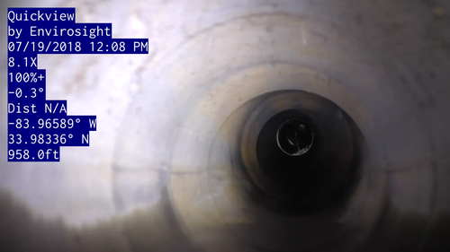
Columbia continually evaluates additional ways to effectively and efficiently meet the needs of our clients. As a part of that, we have invested in a real-time view pole camera to improve our deliverables and provide our clients with the highest quality product. This equipment will allow us to quickly inspect manholes and pipes on the site. It is equipped with a high beam light, an extreme zoom HD camera, and a laser that measures distance.
This new equipment gives us the following abilities:
Determine pipe condition quickly with videos and pictures easily provided the client for reference.
Inspect pipes that a crawler cannot go into due to pipe condition or standing water.
Determine accurate locations of buried structures using the camera and the laser rangefinder.
Improve quality control by allowing desktop verification of survey data.
Minimize risk by limiting need for confined entry.
Surveying
Columbia’s survey services include boundary, topographic, transportation, and route surveys, hydrographic surveys, and infrastructure inventory. Columbia is a demand service consultant for the Gwinnett County (Georgia) Department of Transportation for Survey Services and is pre-qualified by the Georgia Department of Transportation (GDOT) in Area Classes 5.01 Land Surveying, 5.02 Engineering Surveying, and 5.03 Geodetic Surveying. Columbia has provided survey for flood studies in numerous Counties in Georgia over the past 13 years. Columbia’s survey department utilizes the latest surveying equipment including Nikon and Topcon Total Stations and Robotic Equipment, Hiper Pro GPS Base and Rovers, data collectors and current software including AutoCAD, Microstation, InRoads, and ESRI ArcMap.
Types of surveys:
Boundary/Topography/Route Surveys
Construction Staking
ALTA Surveys
Hydrographic Surveys